The History of Citrus Heights
Early History and Native American Presence
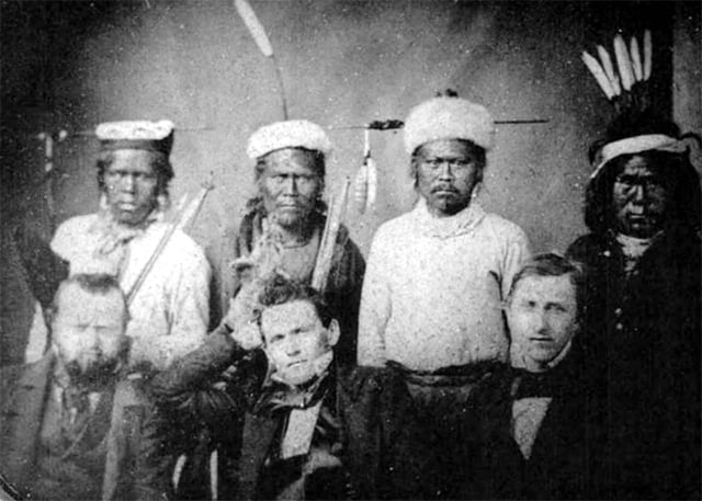
Photo source: “The Savages Were in the Way”: California’s History of Genocide, Truthout (Nov 9 2017)
The Citrus Heights area sits within the broader homeland of the Maidu—often called the Nisenan in the lower Sierra foothills and valley. Villages clustered near dependable water and oak groves, with seasonal rounds to salmon runs, seed meadows, and upland hunting grounds. Houses could be semi‑subterranean in winter villages, complemented by granaries for acorns and seeds.
Acorns from valley oaks were a dietary cornerstone. Families leached tannins with water, then ground the meal for porridges and breads. Basketry—renowned for its craftsmanship—supported food processing, storage, and gathering. Controlled burning maintained open woodlands, stimulated seed plants, reduced pests, and refreshed browse for game, reflecting sophisticated ecological stewardship.
Trade routes connected communities across the valley and foothills. Items such as shell beads, obsidian, pigments, and finished baskets moved across cultural networks, while oral histories and place‑based knowledge encoded navigation, resource timing, and ceremony. The arrival of colonists brought epidemics and displacement, yet Maidu descendants remain in the region and continue cultural revitalization today.
Spanish and Mexican Periods
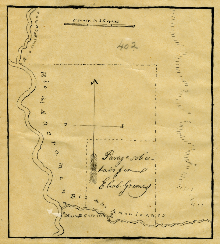
© California State Library
In the late 1700s the region that would become Citrus Heights lay beyond the established Spanish-mission frontier, but it was far from untouched. Spanish expeditions passed through the Sacramento Valley, and the area’s oak savannas, streams, and indigenous trade networks were well known. Although missions were concentrated nearer the coast, Spanish rule asserted legal and territorial frameworks that would have lasting impact.
After Mexico gained independence from Spain in 1821, California’s administration introduced the secularization of mission lands and shifted toward a new ranch-based economy. Under Mexican governance, vast land grants were issued across California. One of these, in 1844, was the massive Rancho del Paso—approximately 44,371 acres—granted to Eliab Grimes, and one of his associates. The grant covered land that now includes parts of north-Sacramento County and the future city of Citrus Heights.
The name Rancho del Paso—Spanish for “the passage”—captured the geography and purpose of this land: a gentle crossing between the Sacramento Valley and the foothill trails leading toward the Sierra Nevada. Through this corridor, herds and wagons moved seasonally, linking early ranchlands to the trading routes and river landings that sustained interior California.
Granted in 1844 under Mexican rule, Rancho del Paso encompassed more than 44,000 acres that included today’s Citrus Heights. Its open range and riparian woodlands supported a vibrant ranching economy built on cattle, wheat, and hides. Life here reflected a fusion of Spanish, Mexican, and Indigenous traditions—horsemanship, craftsmanship, communal labor, and hospitality—creating one of the earliest multicultural landscapes in the Sacramento region.
Latino Californios, vaqueros, and artisans brought generations of skill to the rancho system, introducing methods of irrigation, animal husbandry, and field management suited to California’s Mediterranean climate. Their artistry and stewardship shaped the region’s working rhythm and left enduring marks in the state’s language, place names, and sense of community.
Across this countryside stood adobes, wood-frame dwellings, corrals, and watering places. Indigenous Maidu and Nisenan peoples—whose ancestors had long tended these valleys—interacted with the ranches through trade, labor, and seasonal work, even as land tenure and cultural balance shifted under the pressures of colonization.
The close of the U.S.–Mexico War (1846–1848) and the Treaty of Guadalupe Hidalgo placed California under U.S. sovereignty. The Land Act of 1851 required Mexican land grants to be proven in court; Rancho del Paso’s claim was filed in 1852 and patented in 1858. These legal transitions redefined ownership, opened the door to subdivision, and set the stage for the agricultural communities that would eventually form Citrus Heights.
The legacy of this era endures—in the stories of Latino ranch families, in the layered cultural landscape, and in a shared regional identity that continues to honor both its Hispanic and Indigenous roots.
The Gold Rush and Settlement

When gold was discovered at Sutter’s Mill in Coloma in 1848, just northeast of today’s Citrus Heights, California and the Sacramento Valley changed overnight. Within months, fortune-seekers from across the world poured into the region, transforming a quiet ranching outpost into one of the most dynamic frontiers on the continent. The influx of miners, merchants, and settlers triggered the creation of supply routes, ferry crossings, and trail systems that stitched together what would later become the suburban heart of Sacramento County.
Yet the Gold Rush’s prosperity came with deep human and environmental costs. The Maidu and other Native peoples—who had lived sustainably along the creeks and oak savannas for thousands of years—were forced from ancestral lands by disease, violence, and resource exploitation. Contemporary scholarship and tribal oral histories characterize this era as a critical juncture of cultural loss and displacement for Native communities across Northern California. [Truthout, 2017]
Meanwhile, Sutter’s own fortunes declined as squatters and speculators claimed parcels of his once-vast holdings. Following California’s admission to the Union in 1850, the Rancho del Paso lands were gradually subdivided and sold. The fertile loam soils, reliable groundwater, and mild Mediterranean climate proved ideal for orchards and row crops. German, Swiss, and Midwestern families purchased small tracts to grow fruit, nuts, and grains, establishing the patchwork of farms and lanes that would define the area for the next century.
As the century progressed, small agricultural communities formed around wagon routes and stage stops connecting the foothills to Sacramento. These corridors—later paralleled by Auburn Boulevard and Greenback Lane—became arteries of commerce and migration. Although the Gold Rush had faded by the 1860s, its infrastructure legacy endured: roads, irrigation ditches, and informal trade networks laid the groundwork for the communities that would eventually coalesce into Citrus Heights.
The Gold Rush thus represents both the catalyst for settlement and the beginning of a transformation from Native homeland to agricultural frontier. Its complex legacy is visible today in place names, preserved artifacts, and the enduring spirit that continues to characterize the region.
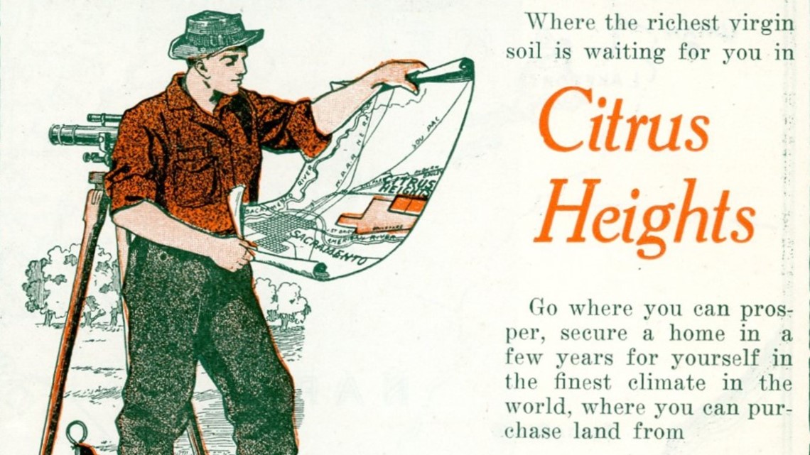
Birth of Citrus Heights (Early 20th Century)

By the early 1900s, the rural landscape that would become Citrus Heights was beginning to take on a more recognizable community identity. Large ranch holdings were increasingly subdivided into smaller farms, orchards, and home sites, allowing more families to settle in the area. What had once been open grazing land and scattered ranch property gradually became a patchwork of agricultural parcels connected by roads, irrigation systems, schools, churches, and local businesses.
Reliable water service played an important role in this transformation. Local water companies, small ditches, wells, and irrigation improvements made it possible for growers to cultivate orchards more consistently across the upland terrain. Citrus crops, especially oranges and lemons, became closely associated with the area, joining walnuts, almonds, olives, grapes, and stone fruits as part of a diversified agricultural economy. The name “Citrus Heights” reflected both the region’s elevated landscape and the orchards that helped define its early identity.
As farming expanded, support businesses followed. Nurseries, packing sheds, blacksmith shops, general stores, and farm-supply outlets appeared near important crossroads, serving growers and residents who needed equipment, repairs, household goods, and access to regional markets. Improved county roads and transportation connections made it easier to move produce toward Sacramento and surrounding communities. These changes helped shift the area from a loose rural district into a more connected settlement with a growing sense of place.
Community life also developed around schools, churches, social clubs, and local events. Families often knew one another through farm work, school activities, civic gatherings, and shared efforts to improve roads, water service, lighting, and public facilities. These local institutions gave residents a reason to organize, advocate, and promote the area as more than farmland on the edge of Sacramento.
In 1910, business and community leaders organized the Citrus Heights Chamber of Commerce, marking an important step in the community’s public identity. The Chamber promoted local commerce, encouraged investment, supported community events, and advocated for infrastructure improvements that would help the area grow. Its formation reflected a broader transition: Citrus Heights was becoming a named community with civic ambitions, commercial activity, and a distinct identity of its own.
During this period, Citrus Heights still retained its rural character, but the foundations of a modern community were already visible. Roads, water systems, agricultural businesses, schools, and civic organizations helped bind the area together. The early twentieth century was therefore not just an agricultural chapter in local history — it was the period when Citrus Heights began to emerge as a recognizable place.
Development & Suburbanization (Mid-20th Century)

In the decades following World War II, the Citrus Heights area entered a period of rapid transformation that would redefine its landscape, economy, and community life. Returning veterans, buoyed by the G.I. Bill and the postwar construction boom, sought affordable homes outside of Sacramento’s increasingly crowded core. Developers quickly recognized the opportunity presented by the area’s rolling terrain, proximity to employment centers, and access to newly expanded highways such as U.S. Route 40 (later Interstate 80).
By the mid-1950s, former orchards and small ranch parcels were being subdivided into modest residential tracts featuring single-story ranch-style homes, curving cul-de-sacs, and community parks. Street names such as Sunrise, Oak, and Mariposa echoed the agricultural and natural heritage of the region even as it urbanized. New schools—like San Juan High School and Arlington Heights Elementary—sprang up to serve the influx of young families, anchoring the area’s first generation of suburban residents.
Shopping centers and small commercial corridors soon followed, creating a self-contained suburban economy that allowed residents to live, work, and shop locally. Among the most significant developments was the construction of Sunrise Mall, which opened in 1972 as one of Northern California’s premier regional retail destinations. Its climate-controlled interior and ample parking reflected the suburban design ideals of the era—automobile accessibility, convenience, and modern comfort.
Transportation improvements were central to this suburban expansion. The conversion of Auburn Boulevard from a rural highway to a major arterial, and the eventual completion of Interstate 80, linked Citrus Heights more directly with downtown Sacramento and the burgeoning suburbs of Placer County. Bus routes and park-and-ride facilities extended regional commuting options, solidifying the area’s role as a vital residential hub in the greater metropolitan network.
During the 1960s and 1970s, civic groups, PTAs, and volunteer fire associations became the social glue of the growing community. Organizations such as the Sunrise Recreation and Park District and local service clubs invested in neighborhood amenities—ball fields, playgrounds, and swimming pools—that embodied the optimism of mid-century suburban life. Churches and small business centers reinforced a sense of belonging among residents who were still technically part of unincorporated Sacramento County.
Architecturally and culturally, Citrus Heights mirrored the American suburban ideal of the era—tree-lined streets, affordable tract homes, and close-knit neighborhoods—but with a distinctly Californian flair. The local economy shifted from agriculture to service and retail, with many residents employed in nearby defense, aerospace, and state government sectors. While the area lacked a formal city government, its residents developed a strong sense of civic identity that would later drive the successful incorporation movement of the 1990s.
By the end of the 1970s, the transformation was unmistakable: the once-rural community of orchards and open range had evolved into a thriving suburban landscape. Yet the enduring community networks and family-oriented character that emerged during this period still define Citrus Heights today—an enduring testament to its postwar growth and grassroots spirit.
Incorporation as a City (1997)
After decades of transformation from a rural farming area into a mature suburb, the residents of Citrus Heights reached a pivotal milestone on January 1, 1997 when the community officially incorporated as the City of Citrus Heights. This achievement marked the culmination of nearly two decades of debate and activism for local control.
The incorporation vote was held on November 5, 1996, passing with about 62.5 percent of voters in favor of cityhood. With this decision, Citrus Heights gained the authority to manage land use, roads, policing, and budgeting — responsibilities that had previously been handled by Sacramento County. For many residents, this was not just a bureaucratic change, but a statement of self-determination and civic pride.
The path to cityhood was anything but easy. Incorporation advocates — most prominently the Citrus Heights Incorporation Project — had spent years organizing, gathering signatures, and countering resistance from Sacramento County officials who feared the fiscal impacts of losing one of their largest unincorporated areas. The process involved multiple legal challenges, including disputes before the Local Agency Formation Commission (LAFCO), which governs city boundary changes in California.
Among the key motivations for incorporation were:
- Local Control: Residents wanted decision-making authority over zoning, roads, and parks, rather than deferring to a distant county government.
- Efficient Services: Many believed a local city council could deliver faster, more accountable services — from code enforcement to recreation programs.
- Fiscal Transparency: Supporters argued that locally managed tax revenues would better reflect neighborhood priorities.
- Community Identity: Civic leaders emphasized that incorporation would affirm Citrus Heights’ distinct identity within the Sacramento metropolitan area.
After the successful vote, five inaugural City Council members were sworn in on January 1, 1997, and the city immediately began operating under a contract city model — contracting with Sacramento County and private entities to deliver essential services while developing its own administrative departments. This efficient model helped stabilize finances during the early years of independence.
The city’s first tasks were ambitious: drafting a General Plan, securing a temporary city hall, negotiating service agreements, and establishing a local police presence. By 2006, Citrus Heights had launched its own Police Department, symbolizing a new level of autonomy and community trust.
Incorporation also opened the door for long-term economic planning and infrastructure development. With zoning power and redevelopment tools, the city was able to guide commercial investment along the Sunrise Boulevard corridor and begin strategic planning for the eventual revitalization of the Sunrise Mall — later reimagined under the “Sunrise Tomorrow” framework.
Cityhood gave residents a tangible sense of ownership. Civic programs like the Citrus Heights Neighborhood Associations (CHNA) and volunteer-driven REACH network emerged, creating new channels for public participation. The annual State of the City address became a forum for celebrating local achievements and reaffirming transparency in governance.
As of today, Citrus Heights remains one of the more recent incorporations among California cities. Its success as a financially stable, self-governing community — without imposing local utility taxes — is often cited as a model of prudent city formation. The effort demonstrated that grassroots civic organization could overcome bureaucracy, laying the groundwork for a responsive local government still evolving nearly three decades later.
Modern Citrus Heights

Today, Citrus Heights is home to more than 87,000 residents and reflects a diverse blend of established suburban neighborhoods, parks, schools, retail corridors, and community gathering places. The city’s physical character is shaped by mid-century subdivisions, mature tree canopies, local shopping centers, and newer infill development, creating a comfortable, human-scaled environment within the larger Sacramento metropolitan area.
Since incorporation, Citrus Heights has continued to define itself as a locally governed city with a strong neighborhood identity. Much of the city was already built out before it became independent, which means modern planning often focuses less on outward expansion and more on reinvestment, infrastructure repair, public safety, commercial revitalization, and improving connections between existing neighborhoods. This gives Citrus Heights a different development story than many newer suburban cities: its future depends largely on how well it renews, adapts, and reimagines places that have served residents for decades.
City planners, civic groups, businesses, and residents have worked to maintain a balance between established community character and modernization. Streetscape improvements, storm-drain upgrades, sidewalk repairs, pedestrian enhancements, bicycle connections, and traffic-safety projects all contribute to a more connected local environment. Public art, park improvements, community events, and neighborhood partnerships also help reinforce the sense that Citrus Heights is not simply a collection of subdivisions, but a city with its own civic identity.
The Sunrise Tomorrow redevelopment effort, centered on the aging Sunrise Mall property, represents one of the most significant planning opportunities in the city’s modern history. For decades, Sunrise Mall served as a major regional retail destination and an economic anchor for the surrounding area. As traditional indoor malls have declined nationwide, the Sunrise property has become a focal point for conversations about housing, employment, entertainment, public space, transportation, and the long-term future of the Sunrise MarketPlace district.
The vision for Sunrise Tomorrow looks beyond the enclosed mall model and imagines a mixed-use district with new housing, retail, restaurants, entertainment, office or employment space, public gathering areas, and green space. If gradually implemented over time, the project could help transform a once auto-oriented retail hub into a more walkable live-work-shop destination. Civic engagement remains central to that process, as residents, property owners, planners, and community stakeholders continue to shape expectations for land use, sustainability, mobility, design, and neighborhood compatibility.
Modern Citrus Heights also continues to draw strength from its longtime community institutions. Parks such as Rusch Park, neighborhood schools, local libraries, service clubs, faith communities, small businesses, and volunteer organizations all play a role in sustaining local identity. Community events, seasonal celebrations, youth programs, and public meetings provide opportunities for residents to remain connected to one another and to the decisions shaping the city’s future.
At the same time, Citrus Heights faces many of the same challenges as other mature suburban communities in California, including aging infrastructure, housing demand, changing retail patterns, transportation needs, and the cost of maintaining public services. These pressures have encouraged a growing focus on practical redevelopment, local economic resilience, neighborhood reinvestment, and better use of existing land and public resources.
Through these combined efforts, Citrus Heights continues to evolve as a connected, forward-looking city that honors its agricultural and suburban roots while planning for a more resilient future. Its modern story is not one of replacing the past, but of adapting the familiar places residents know—parks, streets, shopping centers, civic spaces, and neighborhoods—so they can continue serving the community for generations to come.

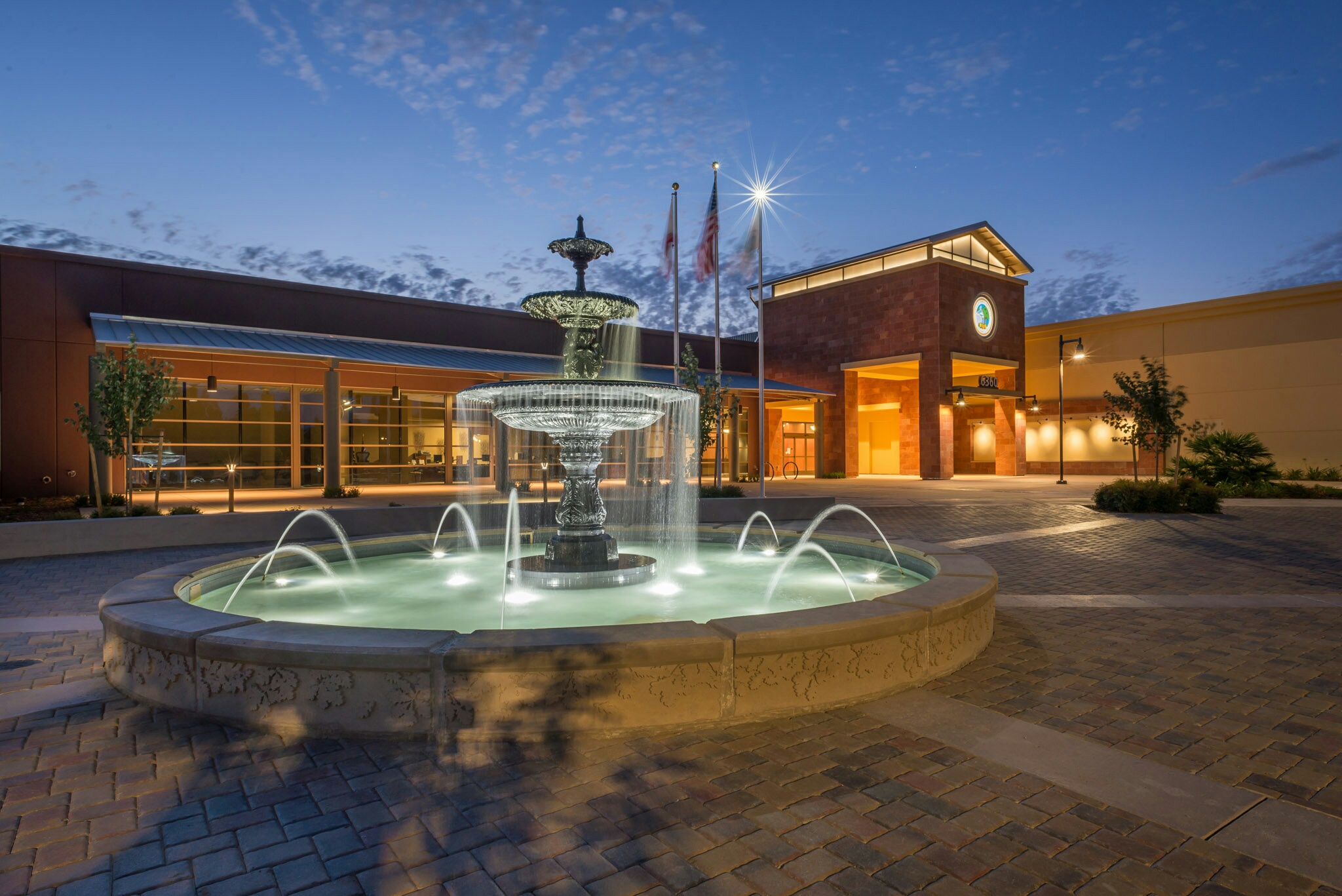
 City of Citrus Heights: Economic Development & Community Engagement